Skip to content

Conservation Law Enforcement

SmartCOP is proud to be the leading provider of enforcement software for Conservation Law Enforcement Officers and Parks and Wildlife Enforcement agencies.

SmartCOP is proud to be the leading provider of conservation law enforcement software for Natural Resource Offices and Parks and Wildlife Enforcement agencies.

Maintain Order in Remote and Rugged Environments

SmartCOP products are trusted by more state conservation law enforcement agencies than any other vendor and are designed to support the diverse responsibilities of Conservation Officers in the field.

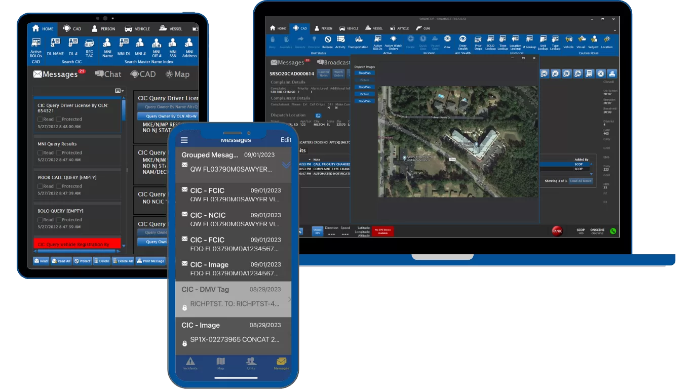
With a single action, officers can query NCIC, the state’s hunting and fishing licensing system, the interstate compact, and the RMS, providing all the necessary information. 

Additionally, embedded ESRI mapping enables officers to access detailed layers of state parks, trails, waterways, and other conservation-specific maps statewide, even while offline.

SmartCAD: Computer Aided Dispatch

Icon for SmartCOP's Computer Aided Dispatch software.

SmartCOP’s natural resource dispatch system (SmartCAD) is the hub of coordination for Conservation and Parks and Wildlife Law Enforcement. With features tailored for remote areas and multi-agency cooperation, it ensures Conservation Law Enforcement can respond efficiently:

  • Track Transportation Method CAD can track whether the unit is in a vehicle, boat, ATV, snow machine, etc., to allow the appropriate one to be selected for dispatch
  • Multiple AVL feeds per unit.  CAD displays the location of the vehicle, boat, officer’s radio, and/or phone app independently on the map
  • Location Validation for off-highway locations, including GPS coordinates, boat docks, lakes, etc.
  • Geographically Tailored Dispatching: AVL integration identifies the closest officers or watercraft to incidents for rapid response.
  • Custom Alerts and Notifications: Automatically notify officers about active violations, poaching hotspots, or high-risk areas.
  • Multi-Jurisdictional Capabilities: Integration across regions for unified enforcement and resource sharing.
With advanced ESRI®-based mapping, the system offers unlimited layers and GIS location validation for precise resource deployment.

SmartRMS: Records Management System

SmartCOP’s Case Management system provides a powerful, configurable workflow that supports unlimited report types, supplements, and attachments, including images and crime scene diagrams.
SmartRMS is a comprehensive records management system that streamlines the reporting of law enforcement case management and operations.

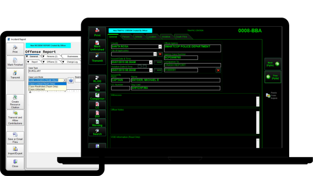
The Records Management System (SmartRMS) is built to simplify the documentation and tracking of conservation law enforcement activities.

  • Conservation-Specific Reports:  Hunting, Boating, Resource, and activity specific
  • Evidence Collection – Property types specific for conservation such as species
  • Case Management: Simplify investigations with detailed records, evidence logging, and chain-of-custody tracking.
  • Offline Functionality: Capture and store data when offline, with automatic syncing once a connection is available.
  • Validation rules to ensure SOP compliant reports
  • Generate NIBRS-compliant reports tailored to conservation enforcement needs.

Track Every Detail with Activity Reports

SmartCOP’s Activity Report makes it easy for conservation law enforcement officers to record and review essential daily operations, ensuring accuracy and accountability in the field.

  • Document license compliance checks, boating safety inspections, and resource protection activities
  • Record hunter education sessions, outreach events, and training efforts
  • Generate clear reports that show activity trends, enforcement focus, and program outcomes

Integrated Citation Disposition & Payments Module

This module includes everything needed to determine if the license should be suspended. 

  • Follows state rules in determining license suspensions and revocations.
  • Keeps up with the number of violations with a Points Review Module with an Enhanced Points Research Tool (The Points Review Wizard) to accommodate name changes and multiple licenses.
  • Administrative Hearings Module and Disposition with Suspensions.
Track, Map, and Investigate derelict vessels.

Available Derelict and At-Risk Vessel Module

  • Track, Map, and Investigate derelict vessels.
  • Track location history, letters & notifications, and threat assessments.
  • Vessel determinations, Natural Disaster Supplements, removal, administrative hearings, and photos & attachments.
  • Related persons, related businesses, and reporting officers. 
  • Officer reminders, report narratives & modules for External Agencies
  • Maintains the Statewide Vessels

Submit Boating Accident Reports Directly to BARD

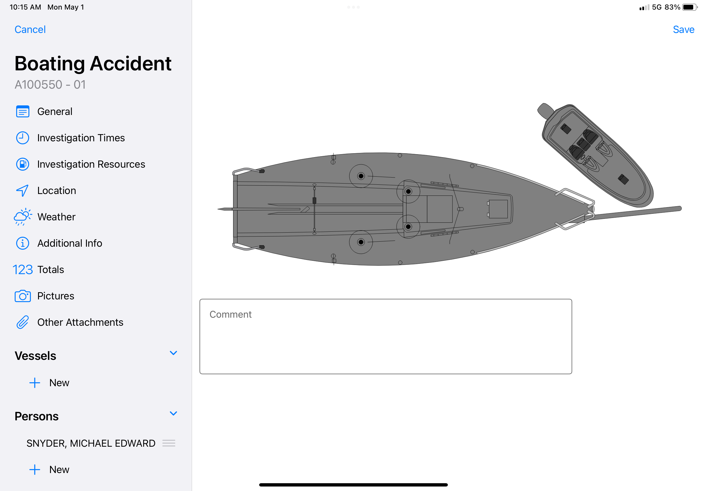
SmartCOP makes it simple for conservation law enforcement agencies to capture, manage, and submit boating accident reports directly to the U.S. Coast Guard’s Boating Accident Report Database (BARD) system.

  • Electronic submission ensures compliance with federal reporting requirements.
  • Integrated workflows reduce duplicate data entry and minimize reporting errors.
  • Faster, more accurate reporting improves safety oversight and supports state and federal waterway enforcement efforts.
SmartCOP makes it simple for agencies to capture, manage, and submit boating accident reports directly to the U.S. Coast Guard’s Boating Accident Report Database (BARD) system.

SmartMOBILE: Mobile Operations

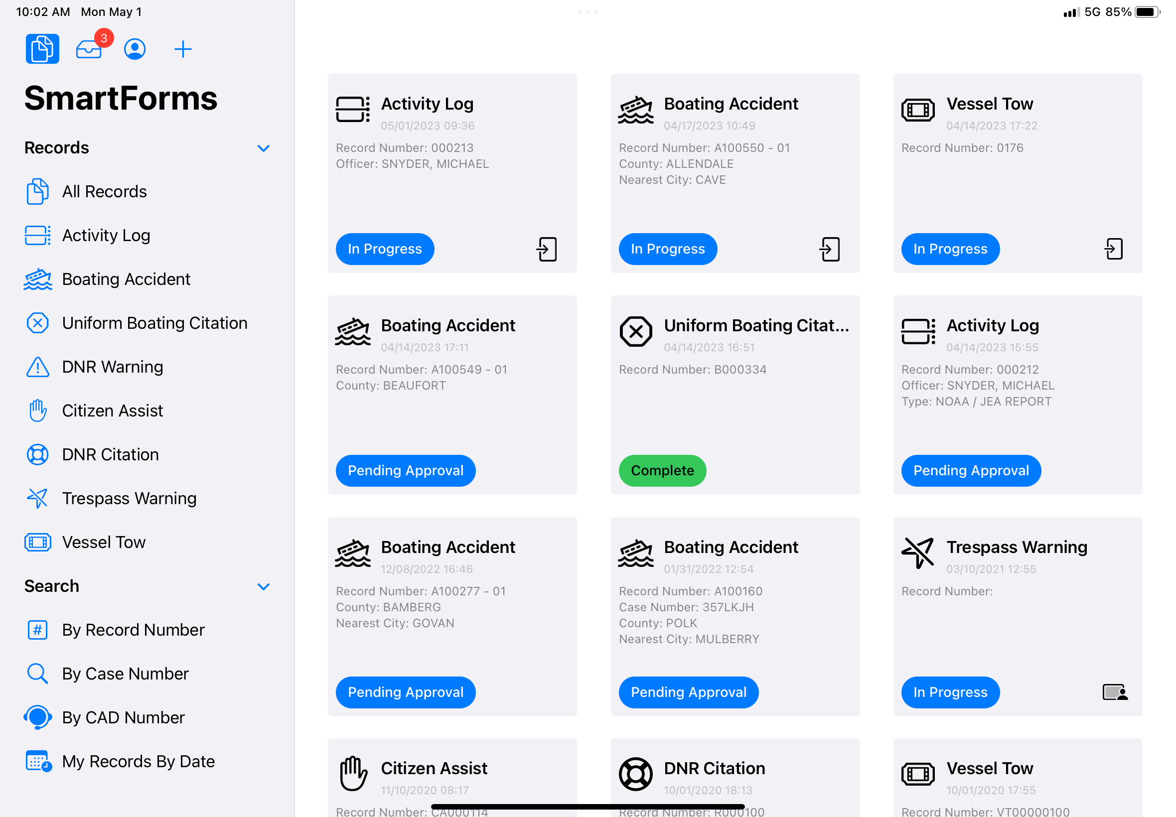
SmartCOP’s Mobile software (SmartMOBILE) keeps Conservation Law Enforcement Officers connected and equipped in the field.

  • CAD Integration: See all information about the assigned event, generate events remotely, and see history on location
  • Map Integration: Real-time maps showing patrol zones, wildlife preserves, and restricted areas.
  • AVL: Send GPS location to CAD from phone, tablet, and laptop all at the same time
  • Officer Safety: Real-time map view of all officer/warden locations at all times
  • Single query will provide results from
    • State Hunting/Fishing License System
    • Interstate Wildlife Violator Compact
    • NCIC
    • Driver License
    • CAD and RMS involvements
  • Secure Messaging: Stay in contact with other officers and command, even in remote locations.
SmartMOBILE enables officers to manage reports efficiently and access real-time data from their mobile devices, improving communication and operational efficiency in the field. Compatible with iOS and Android devices
The mDL (mobile digital driver's license) scanner provides fast, secure, contactless identity verification within the app.

Mobile Driver's License Acceptance (mDL)

SmartCOP provides a fully integrated mobile driver’s license (mDL) interface designed specifically for law enforcement agencies, enabling secure acceptance and use of digital driver’s licenses during traffic stops.

  • Direct Integration: Works with SmartCOP’s SmartRMS and SmartMOBILE app.
  • Secure Digital Capture: Officers can securely scan and capture driver’s license data directly from a driver’s mobile device.
  • Automatic Data Transmission: Captured data is transmitted directly into the agency’s system, eliminating manual typing or re-entry.

SmartADMIN: Administrative Software

SmartCOP's law enforcement admin software, SmartADMIN, offers flexible and user-friendly benefits that streamline operations and improve efficiency.
SmartADMIN offers easy admin management software that simplifies centralized configuration, access management, and record-keeping for administrative support functions.

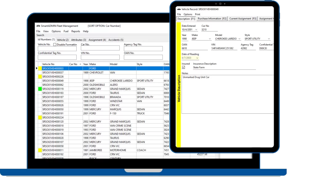
Our Administrative Software (SmartAdmin) simplifies resource and personnel management for Conservation law enforcement agencies.

  • Custom Configuration: Assign permissions and manage workflows specific to conservation enforcement tasks.
  • Resource Allocation: Optimize deployment of officers, vehicles, and watercraft to maximize coverage.
  • Interagency Collaboration: Manage multi-agency operations with ease through shared access and customizable settings.

SmartDATA: Analytics and Reporting

Icon for SmartCOP's Data Analytics and Reporting software - SmartDATA.

SmartCOP’s Analytics and Reporting platform (SmartDATA) increases transparency and public interaction with Conservation law enforcement agencies.

  • License and Permit Checks: Provide an online portal for citizens to verify hunting and fishing licenses.
  • Public Reporting: Allow citizens to report violations, such as illegal hunting or fishing activities, directly online.
  • Secure Data Sharing: Share controlled access to non-sensitive data, like citation records or safety notices, to improve public awareness.
SmartCOP’s law enforcement reporting software provides customizable dashboards that give agencies total visibility into data across their operations.

Available Reports

  • Boating Accident Report (BARD compliant)
  • Boating Citations & Warnings
  • Resource Citations & Warnings
  • Incident Reports
  • Tree Stand Incident Reports
  • Captive Wildlife Reports & Investigations
  • Derelict and At-Risk Vessel
  • NIBRS Reporting
  • Notice to Appear
  • Arrest Reports
  • Hunting Accident Reports
  • Case Management
  • Evidence Management
  • Daily Activity Reporting

System Interfaces

  • Boating Accident Reporting Database (BARD)
  • Interstate Wildlife Violator Compact System Queries (IWVCS)
  • Hunting/Fishing Licensing System Queries
  • NCIC/State CJIS Queries
  • NIBRS Submission

Contact Us for a Custom Quote

SmartCOP’s fully integrated solutions are tailored to meet the unique demands of Conservation Law Enforcement Officers. Whether patrolling state parks, enforcing wildlife regulations, or managing violations on the water, our software provides the tools to protect natural resources, support enforcement efforts, and keep officers connected—anytime, anywhere.

Complete the form to have a member of our team reach out to learn about your needs and how we can help.