Computer Aided Dispatch
SmartCAD – an industry-leading, highly flexible computer aided dispatch system software solution


How SmartCAD Will Benefit You!
Comprehensive
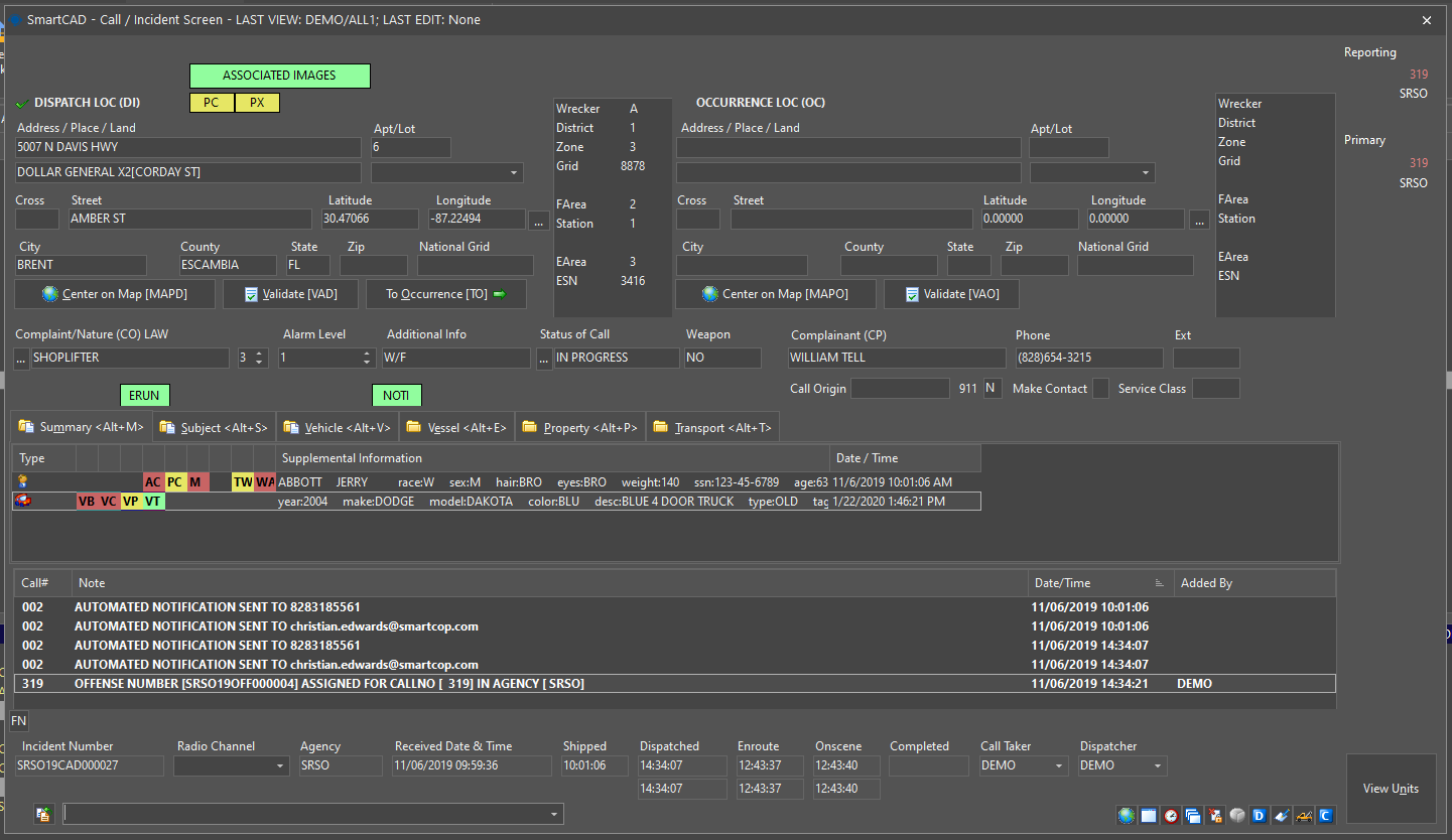
SmartCOP offers a cutting-edge Computer Aided Dispatch (CAD) system that caters to multiple jurisdictions and disciplines within public safety, including law enforcement, fire, EMS, and other agencies. SmartCAD ensures thorough tracking of public safety and emergency calls, as well as effective incident management.
SmartCAD allows dispatchers, administration, or supervisors to track officer movements and deploy quickly to crimes in progress and other calls. With SmartCAD, managing your resources is easier.
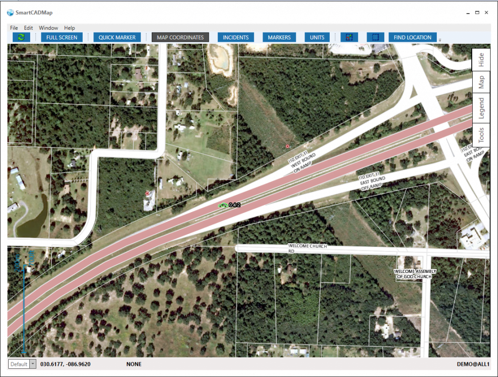
Integrated Mapping
The SmartCAD system utilizes ESRI® technology to provide interactive, real-time map display for call handling, dispatching, unit location, and routing to optimize operations efficiency.
Our CAD system software offers a feature-rich solution that provides flexibility and includes AVL, closest unit recommendations, response plans, run cards, and linked historical data. SmartCAD is easy to use and highly customizable.
Computer Aided Dispatch Features
- Multi-jurisdictional, Multi-discipline
- Command line, function keys, drag and drop
- 911 Integration
- ESRI® based mapping – unlimited layers
- GIS/Map-based location validation
- Closest unit recommendation
- Closest hydrant location
- Automatically sends BOLOs to units in the field
- EMD Software integration (ProQA & APCO)
- Dynamic response plans/run cards for fire & EMS units
- Demographic data collection (citizen contact log)
- Dynamic notification system – SMS/Email/Pager
- Unit timers and status alarms
- Wrecker rotation management
- NCIC integration – paste responses
- AVL allows multiple feeds per unit
- Floor plan/building diagrams
SmartCOP Computer Aided Dispatch System Benefits
Our Computer Aided Dispatch (CAD) system is super easy to use and adapts to how your agency does things. Whether you’re a small team or a big organization, we’ve got you covered! Expect quicker responses and smoother operations with our event-driven setup that sends CAD updates straight to your mobile devices in a flash. Plus, enjoy the convenience of real-time mapping with ESRI integration. And guess what? It’s all seamlessly part of SmartCOP’s Public Safety Suite, making your life easier and your work more efficient!
- Easy to use and learn!
- Configure the system for how your agency conducts business
- Supports agencies of all sizes from very small to large
- Increased efficiency, decreased response time
- Event-driven – CAD info is pushed to mobile as soon as it is entered
- Integrated ESRI mapping allows for a real-time view of calls and units
- Fully and seamlessly integrated with SmartCOP’s Public Safety Suite
Integration Partners for SmartCOP's CAD software
Looking for a Computer Aided Dispatch (CAD) solution that seamlessly integrates with your existing tools? Look no further! Our CAD product offers a plethora of integrations to enhance your workflow. From mapping software to communication platforms and beyond, we’ve got you covered with a wide range of CAD integrations. Say goodbye to siloed systems and hello to streamlined operations. Explore our CAD integrations today and take your efficiency to the next level!
- State CJIS & NCIC Queries
- E911 ANI/ALI
- Seamless SmartRMS data transfer
- Fully integrated with SmartMCT which allows officers to see CAD exactly as it is in dispatch.
- Fully integrated into SmartMOBILE iOS device which helps leadership, Fire, & EMS use CAD.
- SmartCAD API available for integration into other 3rd party systems
- Interfaces with:
- RapidSOS
- APCO Intellcomm
- Priority Dispatch ProQA Paramount
- Smart Horizons Premier Responder
- Fire Incident Systems (FireHouse, EMS Pro, Documed, FirePrograms, & ESO)
- Fire Station Alarming (Motorola MACH ALERT)
- AVL Radio Integration (Motorola UNS)
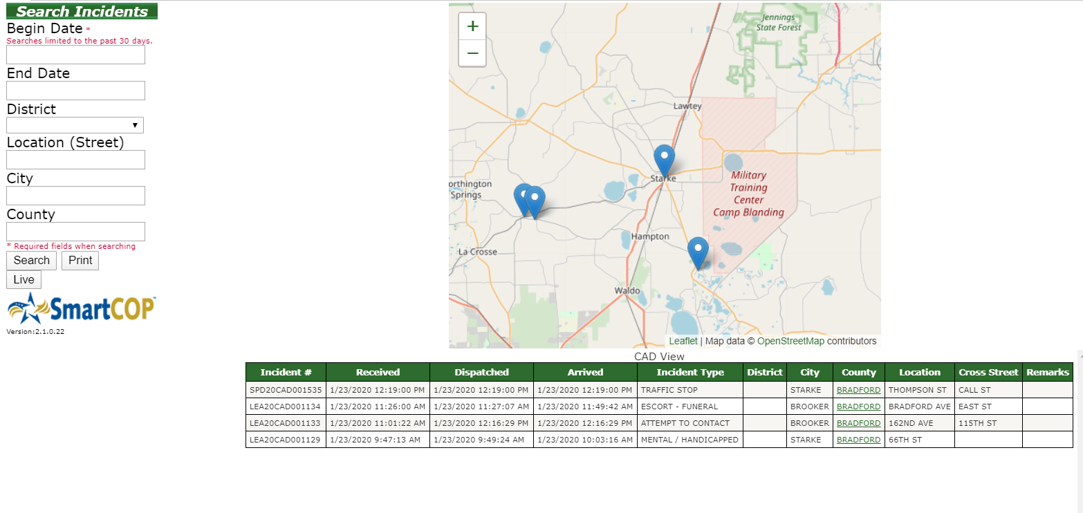
SmartWEB Integration
Ever wished for easy access to live records from CAD, Warrants, or JMS? Look no further than SmartWEB, our awesome public access portal! With just a click, you’ll have all the info you need right at your fingertips. And guess what? SmartWEB doesn’t stop there – it even lets the public report non-emergency crimes directly to your agency, saving you tons of time.
- Agency-defined complaint types available for viewing
- Real-time calls for service
- Historical calls for service
- Google map integration
- Filter options
Learn More
To explore additional features of our Computer Aided Dispatch system application, simply fill out the form provided. To schedule a product demo or inquire further, just click the button below. We’re here to help!